From the InterDev GIS Team
For the past few decades, GIS (Geographic Information Systems) technology has rapidly been developing into an indispensable tool for governments, businesses and consumers.
More recently, we at InterDev have watched GIS grow from visual aids such as crime “hot spot” mapping, land use maps, and site selection analysis to the enterprise-wide storing and managing of critical datasets like addresses, sidewalks, creeks, and streets.
To acknowledge this boom―and to commemorate InterDev’s major expansion into GIS management and staff augmentation, our GIS department is launching its own blog, dedicated to exploring interesting projects being powered by GIS, now.
InterDev has been doing some pretty exciting things with GIS, for municipalities, public safety agencies and other governmental entities around the country. We have helped them explore the technology’s limitless possibilities, pushing the boundaries of typical municipal GIS functions to provide our government customers and their citizens with advanced, intuitive GIS maps and services.
Here are just a few examples of some innovative and interesting projects we have worked on recently.
Tree Canopy Study
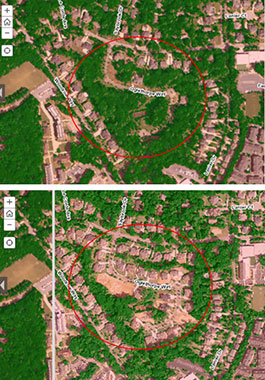 For one of our municipal partners, we created a GIS Tree Canopy Study that shows city officials, staff and citizens, as well as other site viewers, the change in tree canopy from a particular year to another. This is not a static map, it is interactive―users slide a bar back and forth to see the difference, and it is fairly compelling. These studies have been so well received that we are now offering custom development of them for other cities. See the example, below.
Data Mapping Study
This in-house effort may not be as visually interesting as the Tree Study, but it really displays the power of GIS. We took the database from Connectwise, our IT business management platform, and used it to map all of our client locations based on zip codes. We then used that map as a starting point to explore what other external data we could analyze and structure through geography.
Working with Connectwise’s Service Ticket module, we can map the locations of our largest volumes of service tickets. That would let us analyze resources and ensure they were positioned for the most effective customer service, possible.
Tying our financials to the zip code data, we could perform year-over-year analysis of client locations, uncover emerging business, sales or service trends structured by geography, and more.
GIS is incredibly powerful, and it is becoming deeply integrated into everyone’s lives. We are excited about its future, and we will be exploring what GIS can do, and introducing you to more of our projects, with every blog.
To learn more about GIS and how InterDev is making it even more useful to our government and corporate customers, feel free to give us a call at (770) 643-4400 (toll-free 877-841-8069).